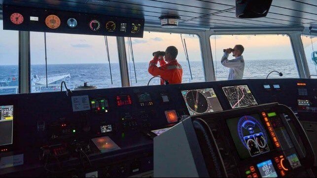
一直以来,海员们依靠导航设备来安全地驾驶船只横渡海洋。
随着科技的发展,在当今科技驱动的世界,现代水手使用的工具也要比前几代人先进得多。
曾经,船员们可以使用磁罗盘导航星空,而21世纪的海员们现在可以使用电子航海图。
它可以通过卫星连接接收近乎实时的更新,从根本上改善了船岸通信。
仅仅依靠纸质海图来绘制的日子已经过去了。现代数字设备和大数据结合,可以优化航线,及时发现如珊瑚礁、冰山和沙洲等潜在的危险;提前改变航线以避免恶劣天气的威胁。
除了使海员能够遵守安全标准外,这些技术还有助于绿色环保等其他行业挑战。
引导航运走向更高效环保的未来
更好地了解我们耐以生存的海洋,从而保护我们的海洋、海岸线和环境以及航运事业,这至关重要。
使用更清洁的燃料和更先进的推进技术将在减少航运的污染影响方面发挥重要作用。
同时,高效安全的导航数据也有助于在短期内提高显著的运营效率。
通过大数据规划的航道可以释放被忽视的潜在效能,减少航程,优化路线,加快港口运营,并实现“更智能的航行”和更准时到达。
研究表明,通过合理的规划,将全球船队的速度降低20%,可能能够将航运的能源消耗减少34%。
这意味着,通过大数据驱动,智能导航的潜力是海运业必须利用的巨大机遇。
为下一代导航系统提供动力
未来的导航解决方案将以国际水文组织(IHO)的新数据标准S-100为基础。通过一个单一、连贯的数据框架,S-100将改变水手和海洋用户查看、共享和使用海洋地理空间数据的方式,提供和谐、高效的资源共享。
S-100数据标准将通过更清晰的测深、水位和地表流数据丰富用户对海洋环境的理解。
这些信息随后将为桥梁团队提供大量可互操作的大数据集和覆盖,以加强通道规划过程的各个阶段。
未来,大数字层甚至可以取代多个航海出版物,进而帮助天气路线和航行优化。
这些更先进的解决方案将成为未来海事不可或缺的一部分,
为海员提供更准确、更及时、更可靠的大数据,并告诉他们实时位置,而不是有延迟的过期位置。
这使海员能够在几分钟内接收到关键的航行事件驱动的更新,而不是几周或几个月,从而显著提高了安全性和操作效率。
新标准也是海道测量行业最新创新浪潮的基石,涵盖航次优化、绿色和数字化航运走廊、自主船舶等。
IHO S-100数据标准的实施已经开始,第一批基于S-100的产品和服务预计将从2026年开始符合运输标准,并从2029年开始强制执行。
此外,随着开发、测试和试验的进行,第一批S-100系列产品和服务已经在准备部署的路上。
在不确定的世界中获得信任
利用数字技术支持安全航行的价值来自于满足现代水手的需求。
未来的海员可能需要与此前几代人完全不同的技能来操作使用了创新人工智能平台和系统的船只。
在安全、可持续地将船只驶向预定目的地时,海员也需要对他们所使用的系统完全有信心。
要做到这一点,唯一的办法就是提供有成功记录的可靠来源的导航数据。
为此,需要继续不断的更新创造,以确保其海事数据解决方案支持当今和未来几代人的导航。
英文原文
Seafarers have always relied on navigational equipment to steer their vessels safely across the oceans.
However, the tools that modern mariners use compared to previous generations are, as expected, far more advanced as a result of today’s tech-driven world.
Where crew members once navigated by the stars using a magnetic compass。
The 21st Century seafarer now has access to Electronic Navigational Charts that can receive near real-time updates via satellite connectivity – radically improving communication between ship and shore.
The days of solely relying on paper charts to plot the safest, most efficient course are behind us.
Crews using the latest digital equipment and data can optimise their voyage, spot potential hazards such as coral reefs, icebergs and sandbars, and change course to avoid weather-related threats.
Aside from enabling seafarers to uphold safety standards, this technology also helps them to address other industry challenges such as decarbonisation.
Steering shipping to a greener future
Better understanding of the marine context in which we operate is essential to protecting our oceans, coastlines and environment, as well as to decarbonising maritime operations.
Cleaner fuels and novel propulsion technologies will play a significant role in reducing shipping’s carbon impact – but high-fidelity navigational data can also help to deliver significant operational efficiencies in the near term.
Data can help to unlock the latent efficiencies in passage planning, enhance voyage and route optimisation.
Expedite port operations, and enable ‘smarter steaming’ and Just-in-Time (JIT) arrivals.
Studies show that by reducing speeds across the global fleet by 20% – which is a potential by-product of JIT – we may be able to reduce shipping’s carbon footprint by 34%.
This means that the potential of smarter navigation, enabled by data-driven efficiencies, is a huge opportunity that the maritime industry must tap into.
Powering next-generation navigational systems
Tomorrow’s navigational solutions will be underpinned by S-100.
The International Hydrographic Organization’s (IHO) new data standard. Through a single, coherent data framework, S-100 will transform the way mariners and ocean users view,
Share and use marine geospatial data – providing harmonised, seamless access.
The S-100 data standard will enrich the user’s view of their marine environment through clearer bathymetric, water levels and su***ce currents data.
That information will subsequently give bridge teams numerous interoperable data sets and overlays to enhance all stages of the passage planning process.
In the future, digital layers could even take the place of multiple nautical publications to aid weather routeing and voyage optimisation.
These next-generation solutions will be an integral part of the maritime future, delivering more accurate, timely and useable data for the mariner and telling them where they are rather than where they were.
This enables seafarers to receive navigationally critical event-driven updates within minutes, rather than weeks or months, providing a demonstrable improvement in safety and operational efficiency.
The new standards are also the building blocks of the hydrographic industry’s latest wave of innovation, spanning voyage optimisation, green and digital shipping corridors, autonomous vessels, and more.
Implementation of the IHO’s S-100 data standard has already begun, with the first S-100 based products and services expected to be carriage compliant from 2026 and mandated from 2029.
Additionally, the first batch of S-100 series products and services are already on their way to being ready for deployment, with development, testing and trialling taking place.
Gaining trust in an uncertain world
The value of harnessing digital technology to support safe navigation comes from meeting the needs of the modern mariner.
Tomorrow’s seafarer will likely require a different skillset from previous generations to operate vessels fitted with innovative AI platforms and systems.
Mariners will also need complete confidence in the systems they use when steering a ship safely and sustainably to their intended destination.
The only way to give them that is to provide navigational data from a trustworthy source with a track-record of success.
To that end, the UKHO continues to innovate to ensure its ADMIRALTY Maritime Data Solutions support navigation today and for generations to come.
免责申明:本文来自:gcaptain.com网站,如有误差以英文为准;仅代表作者观点,不代表中国海员之家立场。其真实性及原创性未能得到中国海员之家证实,在此感谢原作者的辛苦创作,如转载涉及版权等问题,请作者与我们联系,我们将在第一时间处理,谢谢!联系邮箱:cnisu@54seaman.com

 联系我们人工客服


 :1391995811


评论 (0人参与)