简介 Introduction
亚马逊河北航道入口浅滩(BARRA NORTE)参考潮汐站H (0134N, 04913W), 宽约25海里,当局建议高潮安全通过最大吃水11.5M。
Amazon entrance/ Barra Norte shallow water area where is about 25 nm in width and the tide is refer to the station H (0134N, 04913W) and draft restriction is 11.50 meters as a safe draft for crossing Barra Norte at high tide as per authorities advice.
潮汐 Tide
BARRA NORTE浅滩潮汐在H (0134N, 04913W) 站附近的特征如下:(注意此浅滩潮汐表是基于BONTA DO CEU潮汐站的)
在H 站的高潮约比在PONTA DO CEU的高潮提前4小时10分;
在H站的低潮约比在PONTA DO CEU 的低潮提前4小时39分。
可参考以下举例说明。
船舶必须在高潮前一小时到达H站确保安全通过浅滩。
浅滩潮流:涨潮流向为西南向,退潮为东北向。小潮流速约为3节,大潮流速约5.5节。
The tides at the approaches of station H (lat 01.34 n/ long 049.13 w) present following characteristics: (Please noted that Barra Norte tide table is based on Ponta do Ceu station in positions Lat 00-45.6n, Long 050-06.8w)
The high tide occurs approximately four hours and ten minutes (04:10hrs) before the high-tide at Ponta do Ceu station.
The low tide occurs four hours and thirty-nine minutes (04:39 hrs) before the low tide at Ponta do Ceu station.
For example:
If in a determined day, the tide of high tide at Ponta do Ceu occurs at 14hrs and 00 minutes (14:00 hrs) with the value of 3,70 m and the low-tide occurs at 21 hrs and 00 minutes(21:00hrs) with the value of 0,0m,and at the region of approaches station "h" the high-tide will be at 09 hrs and 50 minutes(09:50hrs) and the low-tide will be at 16 hrs and 21 minutes (16:21 hrs).
The correct time to pass is 14:00 – 4:10 = 09:50 LT (GMT -3). Master must arrive at point H about 1 hour before the calculated High Tide.
current rate= the tidal current in Barra Norte flows in a SW direction during flood tide and NE during ebb tide, and runs with3(neap) and 5.5(spring) knots.
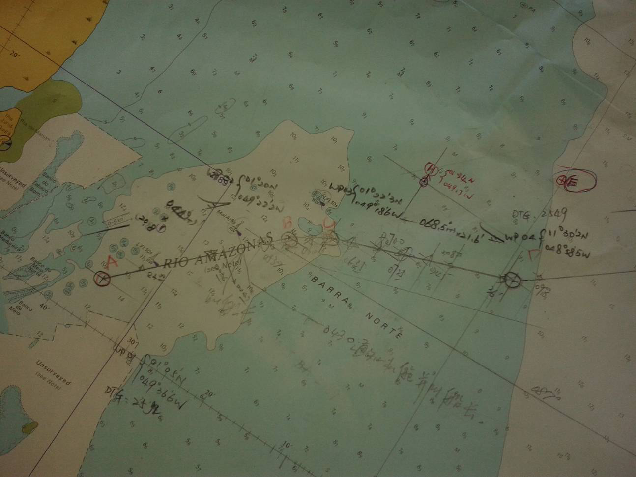
航路简介
根据实践,最佳通过浅滩的航路如下:A - 01˚ 05.0’N, 049˚ 36.6’W;B - 01˚ 20.0’N, 049˚ 22.2’W;C - 01˚ 22.3’N, 049˚ 18,6’W;D - 01˚ 30.2’N, 048˚ 58.5’W
英版海图BA2189 和3962上的以下灯标缺失。
No. 1 - 01-25.40n/ 049-22.20w, white light
No. 2 - 01-17.55n/ 049-27.72w, white light
No. 3 - 01-09.64n/ 049-33.33w, white light
According to practical studies have been carried out with the same masters who experienced transiting that area, the best lane for passage through the shallow waters of Barra Norte are Waypoints: A, B, C, and D.
The follow listed buoyage was found missing on the BA Chart 2189 & 3962. (No.1, 2 & 3)
实践 Practice
我轮于2014年8月3日重载进口,淡水吃水F/10.71, A/10.90M,目的港MANAUS,另于2014年8月23日重载出口, 淡水吃水F/9.8, A/10.20M。
根据潮汐表NP202-2014(有时代理可以提供当地潮汐表,两者略有误差),
03-AUG-2014, PONTA DO CEU, 1651LT ------ 3.5M
23-AUG-2014, PONTA DO CEU, 1108LT ------ 3.8M
则可以得出在浅滩H 点附近区域的潮高如下(时间减04h10m):
03-AUG-2014, BARRA NORTE (H), 1241LT ------ 3.5M
23-AUG-2014, BARRA NORTE (H), 0658LT ------ 3.8M
我轮实际于2014年8月3日1212LT 在E(0143N, 04900W)点起锚,直接驶往C点。顺流,机动全速,航速最高达10节,测深仪显示船底水深0.5米左右。
另于2014年8月23日0600LT到达C 点出口,改为驶往D点。顶流,机动全速,航速保持在8节左右,测深仪显示船底水深1.5米左右。
可作参考的是当我轮出口时,在我轮右边3-4海里平行线上有两艘吃水11.5M 和11.6M的出口船和一艘吃水11.5M的进口船,出口船航速5-6节,进口船约8节。
My vessel arrived at Amazon entrance on 03 Aug 2014 in laden condition, draft in FW F/10.71, A/10.90M, destination Manaus. And then outbound on 23 Aug 2014 in laden condition, draft in FW F/9.8, A/10.2M.
According to Tide Table NP202-2014:
03-AUG-2014, PONTA DO CEU, 1651LT ------ 3.5M
23-AUG-2014, PONTA DO CEU, 1108LT ------ 3.8M
So that the tide at H station should be as follow:
03-AUG-2014, BARRA NORTE (H), 1241LT ------ 3.5M
23-AUG-2014, BARRA NORTE (H), 0658LT ------ 3.8M
In practice, my vessel anchor aweigh at 1212Lt on 03 Aug 2014 in point E (0143N, 04900W), and then directly proceeding to point C (01-22.3N, 049-18.6). Manoeuvring RPM to full ahead with favorable current, maximum speed 10 knots, echo sounding about 0.5 m under keel.
On 23 Aug 2014 about 0600Lt arrived at point C (01-22.3N, 049-18.6), then proceeding to point D (01-30.2N, 048-58.5W), Manoeuvring RPM to full ahead with adverse current, speed about 8 knots, echo sounding about 1.5 m under keel.
For reference only, there are two outbound vessels and one inbound vessel with draft 11.5 m on my starboard and parallel distance about 3-4 miles. It is at speed 5-6 knots for outbound and 8 knots for inbound.
其他 Others
进口手续在FAZENDINHA 引水锚地(A- lat 00-03.5 S long 051-06.9W; B- lat 00-03.5 S long 051-05.8W; C- lat 00-03.7 S long 051-05.8W; D- lat 00-04.3 S long 051-06.9W)办理,需挂检疫黄旗,特别需要注意食品和药品没有过期的!此锚地距离亚马逊入口约170海里,仅为所有船舶办理进口手续以及上下引水所用。沿途没有报告点。
进口手续仅白天办理0800-1700Lt,如果晚上到达或者等待办理进口手续或引水需要现在MACAPA锚地等待。MACAPA锚地沙滩向西移动,据报最近有船舶在下述位置触底:
. 00-03.50N/050-58.25W
. 00-04.87N/050-55.52W
. 00-03.53N/050-58.15W
Fazendinha P.Station anchorage where is close to Santana city and entrance formalities are carried out, and pilots boarding point for proceeding up river. On vessels arrival, pls hoist up the quarantine yellow flag, and check your medicine/food store for any item out of date. In case you find any item out of validity, pls separate it from the store due to quarantine inspection. Distance from Amazon entrance approaches to Fazendinha Pilot Station is about 170 NM. No report required during the way to Fazendinha P/S. Fazendinha p/s is the 1st stop for all vessels entering Amazon River for authorities clearance purposes and pilots embark/disembark only. Entrance formalities are available daylight 0800-1900Lt only. Ship will be anchored at Macapa anchorage waiting for line-up or other instructions. Pls pay more attention to the bank move to West at Macapa anchorage and recently reported that two vessels had been touched down bottom at the following position.
. 00-03.50N/050-58.25W
. 00-04.87N/050-55.52W
. 00-03.53N/050-58.15W