杜阿拉入口浅滩和航道航法及注意事项
简介 Introduction
杜阿拉航道进口浅滩位于航道Wouri灯浮 (0345.0N, 00923.7E) and B3灯浮 (0348.4N, 00925.4E) 之间, 长约3海里,海图水深约7米。杜阿拉狭窄航道从B9灯浮 (0354.3N, 00932.4E) 到泊位,航道长约12海里,最大宽度约150米,航道维护水深约6.2米。泊位水深最好自己测量,据称挖泥船不负责维护距离泊位5米范围内的区域,以免损坏码头。经常有船舶在低潮时座底。
Douala entrance shallow water area where is about 3 nm in length between the fairway buoy Wouri (0345.0N, 00923.7E) and buoy B3 (0348.4N, 00925.4E) and about 7 m above chart datum. The Douala narrow channel is about 12 nm from the buoy B9 (0354.3N, 00932.4E) to the berth with maximum 150 m in width and maintained depth about 6.2 m. It is better to sound the water depth on berth. It is said that the dredger is not responsible for the area to the berth within 5 m so as to avoid any damage to the wharf. Some vessels were often suffered touching bottom on berth at low water.
潮汐 Tide
入口浅滩潮汐时间较之杜阿拉约提前1.5小时,杜阿拉港潮高在0.3-2.9m之间。具体可参考英版潮汐表NP202,其主 港是BONNY TOWN, NIGERIA;也可向代理索要当地的潮汐表。
The tidal time at the entrance shallow is 1.5 hours earlier than the Douala port. The tidal range is between 0.3 m to 2.9 m. Please refer to the Admiralty Tide Table NP-202 for details and the standard port is Bonny Town, Nigeria. The local tide information is also can be got from your agent.
航路简介
根据多艘进出港船舶船长实践,最佳通过浅滩和狭窄航道的航路点如下(进港):
WP01. 03-45.0N, 009-23.7E (Fairway buoy Wouri)
WP02. 03-46.9N, 009-24.5E {Buoy No.2 (R) & No.1 (G), missing}
WP03. 03-49.8N, 009-25.9E
WP04. 03-51.3N, 009-27.6E
WP05. 03-52.5N, 009-30.0E
WP06. 03-54.3N, 009-32.4E
WP07. 03-59.4N, 009-36.7E {Buoy No.22 (R) & No.23 (G)}
WP08. 04-00.9N, 009-38.4E {Buoy No.28 (R) & No.27 (G)}
WP09. 04-01.85N, 009-39.35E {Buoy No.32 (R) & No.31 (G)}
WP10. 04-02.7N, 009-40.65E
WP11. 04-02.97N, 009-41.22E (Berth No.9)
According to practical studies have been carried out with those masters who experienced transiting that area, the best lane for passage through the shallow waters and narrow channel of Douala as follows:
WP01. 03-45.0N, 009-23.7E (Fairway buoy Wouri)
WP02. 03-46.9N, 009-24.5E {Buoy No.2 (R) & No.1 (G), missing}
WP03. 03-49.8N, 009-25.9E
WP04. 03-51.3N, 009-27.6E
WP05. 03-52.5N, 009-30.0E
WP06. 03-54.3N, 009-32.4E {Buoy No.9 (RW), missing, Pilot Station}
WP07. 03-59.4N, 009-36.7E {Buoy No.22 (R) & No.23 (G)}
WP08. 04-00.9N, 009-38.4E {Buoy No.28 (R) & No.27 (G)}
WP09. 04-01.85N, 009-39.35E {Buoy No.32 (R) & No.31 (G)}
WP10. 04-02.7N, 009-40.65E
WP11. 04-02.97N, 009-41.22E (Berth No.9)
实践 Practice
我轮于2015年5月3日空载进口,淡水吃水F/3.6, A/6.1米,靠9号泊位,另于2015年5月24日重载出口, 淡水吃水F/8.0, M/8.1,A/7.9米。虽然多数灯浮缺失,但现存灯浮尚可有效帮助导航,进出港的安全基本还能保证。关键是引水很不负责任,图快省事,需要特别留心。进港时引水通常在过了23号绿浮上船,出港时一般在22号红浮下,不过有时甚至在28号红浮前就离船了!
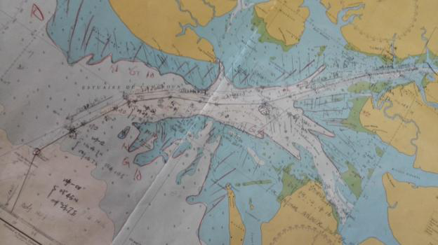
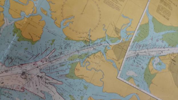
目前还存在的灯浮有航道进口浮Wouri-RW (03-45.0N, 009-23.7E), B10-R (03-55.4N, 009-33.1E), B12-R (03-56.1N, 009-33.7), 以及B6, 22, 23, 31, 32, 33, 34 & 36如英版海图1456所示。
根据英版潮汐表NP202-2015:
03-MAY-2015, DOUALA, 1724LT ------ 2.6M
24-MAY-2014, DOUALA, 2156LT ------ 2.1M
25-MAY-2014, DOUALA, 1100LT ------ 2.2M
则可以得出在浅滩(灯浮B1&2) 附近区域的潮时潮高如下(时间减01h30m):
03-MAY-2015, ENTRANCE SHALLOW WATER (B1&2), 1554LT ------ 2.6M
25-MAY-2015, ENTRANCE SHALLOW WATER (B1&2), 0930LT ------ 2.2M
我轮实际于2014年5月3日1548LT 通过B1&2灯浮(缺失),顺流,机动全速,航速最高达10节,测深仪显示船底水深2.0米左右。约1700LT到达图示引水登轮区域即9号浮(缺失),引水及港调要求进航道继续航行。我轮为第三艘进口船,跟随一艘重载吃水8.1米的集装箱船。同时还有三艘重载出口船,过了14和15号浮后,引水要求最慢速会出口船。在等待会遇出口船期间,引水强调进口船靠航道左侧航行,特别要尽可能远离23号绿浮。但不幸的是,由于进出口船都到达了22和23号浮,我前面的集装箱船在会遇时略微靠近绿浮导致搁浅!到第二天通过拖轮协助才脱浅。
另于2014年5月24日2036LT离港出口,顶流,机动半速,航速保持在5节左右,测深仪显示船底水深0.2米左右。2118LT,引水在28号红浮前离船,尽量靠航道右侧航行。0018LT/25TH,到达内锚地抛锚,25日早上9点左右过浅滩续航。
My vessel was got alongside the berth No.9 on 03 May 2015 in ballast condition with draft in FW F/3.6, A/6.1 m, and then departed on 24 May 2015 in laden condition, draft in FW F/8.0, M/8.1, A/7.9 m. Through much of buoys were missed, the existed buoys are effective to aid navigation safety inbound and outbound. Please pay more attention to the pilots for their careless, irresponsible and impatient. The pilot usually is boarded after passing the Green buoy No.23 inbound and disembarked at R buoy No.22 outbound. Sometimes pilot even disembarked before the Red buoy No.28.
At present, the existed buoys are Wouri-RW (03-45.0N, 009-23.7E), B10-R (03-55.4N, 009-33.1E), B12-R (03-56.1N, 009-33.7) and B6, 22, 23, 31, 32, 33, 34 & 36 as shown on the BA chart No.1456.
According to the Admiralty Tide Table NP202-2015:
03-MAY-2015, DOUALA, 1724LT ------ 2.6M
24-MAY-2014, DOUALA, 2156LT ------ 2.1M
25-MAY-2014, DOUALA, 1100LT ------ 2.2M
So that the tide at shallow water (Buoy No.1 & 2) as follow:
03-MAY-2015, ENTRANCE SHALLOW WATER (B1&2), 1554LT ------ 2.6M
25-MAY-2015, ENTRANCE SHALLOW WATER (B1&2), 0930LT ------ 2.2M
In practice, my vessel passed actually the buoy B1&2 at 1548Lt on 03 May 2015, favourable current, manoeuvring full speed to 10 knots, and echo sounder displayed the depth is about 2.0 m under keel. At about 1700Lt, arrived at the pilot boarding area (Buoy No.9, missed) but pilot and port control asked to enter the channel proceeding to the Buoy No.23 (G). My vessel is the third inbound ship and follows up a laden container with draft 8.1 m. At the same time 3 outbound vessels are come out with pilot on board. The pilot required all inbound vessel minimum speed to meet outbound vessel after passing the buoy No.14 & 15. And pilot stressed that inbound vessel should be navigated on the left channel and especially keep as far as possible from the green buoy No.23 when waiting for the outbound vessel. Unfortunately, because inbound and outbound vessel arrived at buoy No.22 & 23 together, the container ahead of me was grounded when she met the outbound vessel due to little closed to the green buoy. And she was final taken off with tugs assistance next day.
My vessel departed from berth at 2036Lt on 24 May 2015, adverse current, manoeuvring half speed with about 5 knots, echo sounder displayed the depth is about 0.2 m under keel. At about 2118Lt, pilot disembarked closed to the red buoy No.28 and then keep navigating on the starboard of the channel as possible. At about 0018Lt on 25th, dropped anchor at the inner anchorage. To pass the shallow water at about 0900Lt on 25th and then proceed to next port
其他 Others
杜阿拉港口压港比较严重,我轮在锚地等了近两个月才进港。其图示锚地在进口浅滩之内,锚地狭窄流急船多,尤其5-7号浮附近位置容易走锚,所以不建议一开始就进内锚地抛锚。
航道进口浅滩外以南及东南方向有很宽阔的水域都很适合锚泊,只需报告港调就可以了。如果需要进内锚地等待进港,港调都会提前通知。
港口总体说来还可以,进口手续断断续续,各有关部门分批上船,人员众多,拖延时间较长,主要找麻烦敲诈船上的是MARPOL防污染部门和PSC,多数情况需要现金解决。经常移泊,感觉对面的码头小偷多些,需要加强防范。装货(原木)技术还不错,24小时作业但不粗野。
My vessel has to wait for about two month at anchorage before getting alongside the berth for loading logs due to heavy congestion at Douala. The anchorage where is positioned inner narrow channel, swift current and lots of ship. It often happened dragging nearby the buoy No.5 & 7. In this case, it is not recommended to drop anchor at the inner anchorage on arrival.
It is suitable and wide to anchor at the S & SE of the entrance fairway buoy (outside of the shallow water) and just report to the port control on VHF16 before you do it. The port control will inform you in advance if you need to anchor at the inner anchorage for berthing.
Generally, Douala is good port. The port entry formalities will be last for one or two days due to the port authorities come on board separately with many persons. It should pay more attention to the MARPOL department and PSC.
Shifting will be experienced too much during loading logs. Keep vigilance to prevent thief and stowaway all times. Stevedores are OK for loading logs; they are working 24 hrs and handling carefully.

BA Chart 1456

BA Chart 1456
请登录后发帖

 联系我们人工客服


 :1391995811

