第1号
现将经修订的《琼州海峡船舶定线制》和《琼州海峡船舶报告制》予以公告,自2022年4月1日起实施,请相关单位和航经该水域船舶遵照执行。
中华人民共和国海事局
2022年2月10日
琼州海峡船舶定线制
参考海图:中华人民共和国海事局海图图号01103、88001、3315,中国人民解放军海军参谋部航海保证局海图图号15770。
本定线制坐标点采用2000国家大地坐标系(航海用途等同于WGS-84世界大地坐标系)。
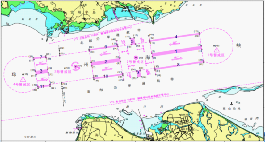
琼州海峡船舶定线制由分隔带、边界线、通航分道、警戒区、避航区、推荐航线、环形道和沿岸通航带组成。
1.分隔带
定线制分隔带由1号、2号、3号、4号、5号、6号、7号、8号、9号、10号、11号共11个分隔带组成。
1.1 1号分隔带为下列四点连成的水域,宽度为0.4海里。
(1) 20°11′.88N, 110°22′.38E
(2) 20°11′.06N, 110°16′.83E
(3) 20°10′.66N, 110°16′.90E
(4) 20°11′.49N, 110°22′.43E
1.2 2号分隔带为下列四点连成的水域,宽度为0.4海里。
(5) 20°10′.51N, 110°13′.27E
(6) 20°10′.02N, 110°10′.07E
(7) 20°09′.63N, 110°10′.13E
(8) 20°10′.11N, 110°13′.34E
1.3 3号分隔带为下列四点连成的水域,宽度为0.4海里。
(9) 20°09′.26N, 110°05′.22E
(10) 20°09′.06N, 110°03′.86E
(11) 20°08′.66N, 110°03′.92E
(12) 20°08′.87N, 110°05′.28E
1.4 4号分隔带为下列四点连成的水域,宽度为0.2海里。
(13) 20°13′.35N, 110°22′.15E
(14) 20°12′.51N, 110°16′.58E
(15) 20°12′.32N, 110°16′.61E
(16) 20°13′.15N, 110°22′.18E
1.5 5号分隔带为下列四点连成的水域,宽度为0.4海里。
(17) 20°12′.78N, 110°14′.88E
(18) 20°12′.72N, 110°14′.45E
(19) 20°12′.02N, 110°14′.58E
(20) 20°12′.08N, 110°15′.02E
1.6 6号分隔带为下列四点连成的水域,宽度为0.2海里。
(21) 20°11′.99N, 110°13′.00E
(22) 20°11′.50N, 110°09′.82E
(23) 20°11′.32N, 110°09′.85E
(24) 20°11′.80N, 110°13′.04E
1.7 7号分隔带为下列四点连成的水域,宽度为0.2海里。
(25) 20°10′.74N, 110°04′.99E
(26) 20°10′.56N, 110°03′.63E
(27) 20°10′.36N, 110°03′.67E
(28) 20°10′.55N, 110°05′.02E
1.8 8号分隔带为下列四点连成的水域,宽度为0.2海里。
(29) 20°10′.19N, 110°22′.63E
(30) 20°09′.36N, 110°17′.16E
(31) 20°09′.17N, 110°17′.20E
(32) 20°10′.00N, 110°22′.66E
1.9 9号分隔带为下列四点连成的水域,宽度为0.4海里。
(33) 20°09′.13N, 110°15′.55E
(34) 20°09′.07N, 110°15′.12E
(35) 20°08′.36N, 110°15′.25E
(36) 20°08′.43N, 110°15′.68E
1.10 10号分隔带为下列四点连成的水域,宽度为0.2海里。
(37) 20°08′.81N, 110°13′.58E
(38) 20°08′.33N, 110°10′.34E
(39) 20°08′.15N, 110°10′.38E
(40) 20°08′.63N, 110°13′.61E
1.11 11号分隔带为下列四点连成的水域,宽度为0.2海里。
(41) 20°07′.58N, 110°05′.48E
(42) 20°07′.37N, 110°04′.12E
(43) 20°07′.17N, 110°04′.15E
(44) 20°07′.38N, 110°05′.50E
2.边界线
2.1 东北边界线为下列两点的连线:
(14) 20°12′.51N, 110°16′.58E
(45) 20°13′.01N, 110°16′.51E
2.2 西北边界线为下列两点的连线:
(21) 20°11′.99N, 110°13′.00E
(46) 20°12′.46N, 110°12′.92E
2.3 西南边界线为下列两点的连线:
(40) 20°08′.63N, 110°13′.61E
(47) 20°08′.08N, 110°13′.71E
2.4 东南边界线为下列两点的连线:
(31) 20°09′.17N, 110°17′.20E
(48) 20°08′.68N, 110°17′.29E
3.通航分道
3.1 西行通航分道为1号、2号、3号分隔带与相对应的4号、6号、7号分隔带之间的水域,宽为1.3海里,主交通流向为261°。
3.2 东行通航分道为1号、2号、3号分隔带与相对应的8号、10号、11号分隔带之间的水域,宽为1.3海里,主交通流向为081°。
3.3 北上通航分道为5号分隔带与4号分隔带、东北边界线之间的水域,以及9号分隔带与8号分隔带、东南边界线之间的水域,宽为1.5海里,主交通流向为350°。
3.4 南下通航分道为5号分隔带与6号分隔带、西北边界线之间的水域,以及9号分隔带与10号分隔带、西南边界线之间的水域,宽为1.5海里,主交通流向为170°。
4.警戒区
4.1 1号警戒区为以49号点(20°11'.88N/110°23'.80E)为圆心、半径2海里的圆弧与下列四点连线围成的水域。
(16) 20°13′.15N, 110°22′.18E
(1) 20°11′.88N, 110°22′.38E
(4) 20°11′.49N, 110°22′.43E
(29) 20°10′.19N, 110°22′.63E
4.2 2号警戒区为下列十二个点依次连线围成的水域。
(15) 20°12′.32N, 110°16′.61E
(20) 20°12′.08N, 110°15′.02E
(19) 20°12′.02N, 110°14′.58E
(24) 20°11′.80N, 110°13′.04E
(5) 20°10′.51N, 110°13′.27E
(8) 20°10′.11N, 110°13′.34E
(37) 20°08′.81N, 110°13′.58E
(34) 20°09′.07N, 110°15′.12E
(33) 20°09′.13N, 110°15′.55E
(30) 20°09′.36N, 110°17′.16E
(3) 20°10′.66N, 110°16′.90E
(2) 20°11′.06N, 110°16′.83E
4.3 3号警戒区为下列八个点依次连线围成的水域。
(23) 20°11′.32N, 110°09′.85E
(28) 20°10′.55N, 110°05′.02E
(9) 20°09′.26N, 110°05′.22E
(12) 20°08′.87N, 110°05′.28E
(41) 20°07′.58N, 110°05′.48E
(38) 20°08′.33N, 110°10′.34E
(7) 20°09′.63N, 110°10′.13E
(6) 20°10′.02N, 110°10′.07E
4.4 4号警戒区为以53号点(20°08'.69N/ 110°02'.45E)为圆心、半径2海里的圆弧与下列四点连线围成的水域。
(27) 20°10′.36N, 110°03′.67E
(10) 20°09′.06N, 110°03′.86E
(11) 20°08′.66N, 110°03′.92E
(42) 20°07′.37N, 110°04′.12E
5.避航区
5.1 1号避航区是以50号点(20°10'.56N/110°15'.07E)为圆心、半径0.2海里的水域。
5.2 2号避航区是以51号点(20°09'.55N/110°08'.33E)为圆心、半径0.2海里的水域。
6.推荐航线
来往于湛江港徐闻港区粤海铁北港和海口港新海港区粤海轮渡南港的船舶的推荐航线为(54)(55)点之间和(56)(57)点之间的连线:
(54) 20°11′.54N, 110°06′.49E
(55) 20°10′.79N, 110°06′.55E
(56) 20°07′.78N, 110°06′.78E
(57) 20°07′.11N, 110°06′.84E
真航向176°—356°,航至3号警戒区时,应在52号点(20°09′.36N/110°07′.12E)的西侧驶过。
7.环形道
在3号警戒区设立环形道。环形道是以2号避航区为中心的环形通道,船舶应沿环形通道逆时针方向航行。
8.沿岸通航带
8.1 北部沿岸通航带为4号分隔带、6号分隔带、7号分隔带与雷州半岛海岸线之间的水域。
8.2 南部沿岸通航带为8号分隔带、10号分隔带、11号分隔带与海南岛海岸线之间的水域。
9.特别规定
9.1 使用本定线制水域航行的船舶,不免除其遵守《1972年国际海上避碰规则》所规定的各项责任和义务。
9.2 禁止在警戒区、通航分道水域锚泊、捕捞和养殖。
9.3 船舶应尽可能避免穿越通航分道,但如不得***越时,应向主管机关报告。
9.4 对不遵守本定线制的船舶,由主管机关依据相关法律、法规和规章进行处理。
Ships' Routeing System of Qiongzhou Strait
(Revision)
Reference charts: Charts No.01103/88001/3315 by the Maritime Safety Administration of the People’s Republic of China, and Chart No.15770 by the Navigation Guarantee Bureau of the PLA Navy Staff Department.
The coordinate points of this routeing system adopt the National Geodetic Coordinate System 2000 (Navigational purposes are equivalent to WGS-84 World Geodetic Coordinate System).
This routeing system consists of Separation Zones, Boundary Lines, Traffic Lanes, Precautionary Areas, Areas to be Avoided, Recommended Routes, Roundabout and Inshore Traffic Zones.
Separation Zone
1.1 No.1 Separation Zone, 0.4 nautical miles wide, is bounded by the line connecting the following four geographical positions.
(1) 20°11'.88N, 110°22'.38E
(2) 20°11'.06N, 110°16'.83E
(3) 20°10'.66N, 110°16'.90E
(4) 20°11'.49N, 110°22'.43E
1.2 No.2 Separation Zone, 0.4 nautical miles wide, is bounded by the line connecting the following four geographical positions.
(5) 20°10'.51N, 110°13'.27E
(6) 20°10'.02N, 110°10'.07E
(7) 20°09'.63N, 110°10'.13E
(8) 20°10'.11N, 110°13'.34E
1.3 No.3 Separation Zone, 0.4 nautical miles wide, is bounded by the line connecting the following four geographical positions.
(9) 20°09'.26N, 110°05'.22E
(10) 20°09'.06N, 110°03'.86E
(11) 20°08'.66N, 110°03'.92E
(12) 20°08'.87N, 110°05'.28E
1.4 No.4 Separation Zone, 0.2 nautical miles wide, is bounded by the line connecting the following four geographical positions.
(13) 20°13'.35N, 110°22'.15E
(14) 20°12'.51N, 110°16'.58E
(15) 20°12'.32N, 110°16'.61E
(16) 20°13'.15N, 110°22'.18E
1.5 No.5 Separation Zone, 0.4 nautical miles wide, is bounded by the line connecting the following four geographical positions.
(17) 20°12'.78N, 110°14'.88E
(18) 20°12'.72N, 110°14'.45E
(19) 20°12'.02N, 110°14'.58E
(20) 20°12'.08N, 110°15'.02E
1.6 No.6 Separation Zone, 0.2 nautical miles wide, is bounded by the line connecting the following four geographical positions.
(21) 20°11'.99N, 110°13'.00E
(22) 20°11'.50N, 110°09'.82E
(23) 20°11'.32N, 110°09'.85E
(24) 20°11'.80N, 110°13'.04E
1.7 No.7 Separation Zone, 0.2 nautical miles wide, is bounded by the line connecting the following four geographical positions.
(25) 20°10'.74N, 110°04'.99E
(26) 20°10'.56N, 110°03'.63E
(27) 20°10'.36N, 110°03'.67E
(28) 20°10'.55N, 110°05'.02E
1.8 No.8 Separation Zone, 0.2 nautical miles wide, is bounded by the line connecting the following four geographical positions.
(29) 20°10'.19N, 110°22'.63E
(30) 20°09'.36N, 110°17'.16E
(31) 20°09'.17N, 110°17'.20E
(32) 20°10'.00N, 110°22'.66E
1.9 No.9 Separation Zone, 0.4 nautical miles wide, is bounded by the line connecting the following four geographical positions.
(33) 20°09'.13N, 110°15'.55E
(34) 20°09'.07N, 110°15'.12E
(35) 20°08'.36N, 110°15'.25E
(36) 20°08'.43N, 110°15'.68E
1.10 No.10 Separation Zone, 0.2 nautical miles wide, is bounded by the line connecting the following four geographical positions.
(37) 20°08'.81N, 110°13'.58E
(38) 20°08'.33N, 110°10'.34E
(39) 20°08'.15N, 110°10'.38E
(40) 20°08'.63N, 110°13'.61E
1.11 No.11 Separation Zone, 0.2 nautical miles wide, is bounded by the line connecting the following four geographical positions.
(41) 20°07'.58N, 110°05'.48E
(42) 20°07'.37N, 110°04'.12E
(43) 20°07'.17N, 110°04'.15E
(44) 20°07'.38N, 110°05'.50E
2. Boundary Line
2.1 The Northeast Boundary Line is the line connecting the following two geographical positions:
(14) 20°12'.51N, 110°16'.58E
(45) 20°13'.01N, 110°16'.51E
2.2 The Northwest Boundary Line is the line connecting the following two geographical positions:
(21) 20°11'.99N, 110°13'.00E
(46) 20°12'.46N, 110°12'.92E
2.3 The Southwest Boundary Line is the line connecting the following two geographical positions:
(40) 20°08'.63N, 110°13'.61E
(47) 20°08'.08N, 110°13'.71E
2.4 The Southeast Boundary Line is the line connecting the following two geographical positions:
(31) 20°09'.17N, 110°17'.20E
(48) 20°08'.68N, 110°17'.29E
3. Traffic Lane
3.1 The westbound traffic lane is the area between No.1, 2 & 3 Separation Zones and No.4, 6 & 7 Separation Zones, with the width of 1.3 nautical miles, and the main traffic direction is 261°.
3.2 The eastbound traffic lane is the area between No.1, 2 & 3 Separation Zones and No.8, 10 & 11 Separation Zones, with the width of 1.3 nautical miles, and the main traffic direction is 081°.
3.3 The northbound traffic lane, is the area between No.5 Separation Zone, No.4 Separation Zone & the Northeast Boundary Line, and No.9 Separation Zone, No.8 Separation Zone & the Southeast Boundary Line, with the width of 1.5 nautical miles, and the main traffic direction is 350°.
3.4 The southbound traffic lane, is the area between No.5 Separation Zone, No.6 Separation Zone & the Northwest Boundary Line, and No.9 Separation Zone, No.10 Separation Zone & the Southwest Boundary Line, with the width of 1.5 nautical miles, and the main traffic direction is 170°.
4 Precautionary Area
4.1 No.1 Precautionary Area is bounded by the arc centered on No.49 geographical position (20°11'.88N/110°23'.80E) with the radius of 2 nautical miles, and the line connecting the following four geographical positions successively.
(16) 20°13'.15N, 110°22'.18E
(1) 20°11'.88N, 110°22'.38E
(4) 20°11'.49N, 110°22'.43E
(29) 20°10'.19N, 110°22'.63E
4.2 No.2 Precautionary Area is bounded by the line connecting the following twelve geographical positions successively.
(15) 20°12'.32N, 110°16'.61E
(20) 20°12'.08N, 110°15'.02E
(19) 20°12'.02N, 110°14'.58E
(24) 20°11'.80N, 110°13'.04E
(5) 20°10'.51N, 110°13'.27E
(8) 20°10'.11N, 110°13'.34E
(37) 20°08'.81N, 110°13'.58E
(34) 20°09'.07N, 110°15'.12E
(33) 20°09'.13N, 110°15'.55E
(30) 20°09'.36N, 110°17'.16E
(3) 20°10'.66N, 110°16'.90E
(2) 20°11'.06N, 110°16'.83E
4.3 No.3 Precautionary Area is bounded by the line connecting the following eight geographical positions successively.
(23) 20°11'.32N, 110°09'.85E
(28) 20°10'.55N, 110°05'.02E
(9) 20°09'.26N, 110°05'.22E
(12) 20°08'.87N, 110°05'.28E
(41) 20°07'.58N, 110°05'.48E
(38) 20°08'.33N, 110°10'.34E
(7) 20°09'.63N, 110°10'.13E
(6) 20°10'.02N, 110°10'.07E
4.4 No.4 Precautionary Area is bounded by the arc centered on No.53 geographical position (20°08'.69N/110°02'.45E) with the radius of 2 nautical miles, and the line connecting the following four geographical positions successively.
(27) 20°10'.36N, 110°03'.67E
(10) 20°09'.06N, 110°03'.86E
(11) 20°08'.66N, 110°03'.92E
(42) 20°07'.37N, 110°04'.12E
5. Area to be Avoided
5.1 No.1 Area to be Avoided is bounded by the circle centered on No.50 geographical position (20°10'.56N/110°15'.07E) with the radius of 0.2 nautical miles.
5.2 No.2 Area to be Avoided is bounded by the circle centered on No.51 geographical position (20°09'.55N/110°08'.33E) with the radius of 0.2 nautical miles.
6. Recommended Route
Vessels navigating between Yue Hai Ferry North Harbour, Xu Wen harbour area of Zhan Jiang Port and Yue Hai Ferry South Harbour, Xin Hai harbour area of Hai Kou Port should follow the Recommended Routes connecting No.54 and No.55 geographical positions as well as No.56 and No. 57 geographical positions:
(54) 20°11'.54N, 110°06'.49E
(55) 20°10'.79N, 110°06'.55E
(56) 20°07'.78N, 110°06'.78E
(57) 20°07'.11N, 110°06'.84E
Ships with true course 176°-356° should pass on the west side of No.52 geographical position (20°09'.36N/110°07'.12E) in No.3 Precautionary Area.
The Roundabout
The Roundabout is established in No.3 Precautionary Area, centering on No.2 Area to be avoided. Ships should sail along the roundabout counterclockwise.
Inshore Traffic Zone
The Northern inshore traffic zone is the area bounded by No.4 Separation Zone, No.6 Separation Zone, No.7 Separation Zone and the Coastline of Leizhou Peninsula.
The Southern inshore traffic zone is the area bounded by No.8 Separation Zone, No.10 Separation Zone, No.11 Separation Zone and the Coastline of Hainan Island.
Special provisions
9.1 Participating ships shall not be exempted from the responsibilities and obligations under the International Regulations for Preventing Collision at Sea, 1972.
9.2 Fishing ships are prohibited from anchoring, fishing and farming in the Precautionary Areas and Traffic Lanes.
9.3 Ships should, so far as practicable, avoid crossing traffic lanes, but if obliged to do so, shall report to the competent authority in advance.
9.4 Ships in violation of this Routeing System shall be subject to penalties by the competent authority in accordance with relevant laws, regulations and rules.
图1 琼州海峡船舶定线制示意图
琼州海峡船舶报告制
1. 适用的船舶
适用本强制性船舶报告制的船舶为:
1.1 客船;
1.2 外国籍船舶;
1.3 危险品船舶、载运污染危害性货物的船舶;
1.4 从事拖带的船舶;
1.5 操纵能力受到限制的船舶;
1.6 300总吨及以上的其他船舶。
2. 适用的地理范围及相关海图
2.1 适用的地理范围
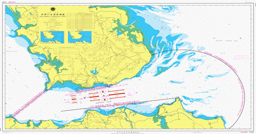
本报告制适用的地理覆盖范围是以木栏头灯塔(地理位置为20°09′.60N, 110°41′.07E)为圆心、22海里为半径的圆弧线;临高角灯塔(地理位置为20°00′.63N, 109°42′.70E)和灯楼角灯塔(地理位置为20°13′.47N, 109°55′.12E)的连线以及琼州海峡岸线之间水域。
2.2 相关海图
中国人民解放军海军参谋部航海保证局海图图号15770;
中华人民共和国海事局海图图号88001。
3. 报告格式、报告内容、报告线和报告要求
3.1 报告格式
本船舶报告制格式采用IMO A.851(20)号大会决议附则中所规定的格式。
3.2 报告内容
A 船名、呼号和国际海事组织编码(若适用)
C或D 位置(经纬度或相对于陆标的位置)
E 航向
F 航速
G 上一停靠港
I 目的港
O 吃水
Q 缺陷及限制(拖船应报告其拖带长度及被拖物名称)
DG 危险货物
U 总长及总吨
船舶装有AIS设备且工作正常,仅需报告以下内容:
A 船名、呼号
G 上一停靠港
I 目的港
O 吃水
Q 缺陷及限制(拖船应报告其拖带长度及被拖物名称)
DG 危险货物
3.3 报告线
3.3.1 东报告线
以木栏头灯塔(地理位置为20°09′.60N, 110°41′.07E)为圆心,22海里为半径向北、向东所画的圆弧与岸线连接的弧线。
3.3.2 西报告线
临高角灯塔(地理位置为20°00′.63N, 109°42′.70E)与灯楼角灯塔(地理位置为20°13′.47N, 109°55′.12E)的连线。
3.3.3 南报告线
木栏头灯塔(地理位置为20°09′.60N, 110°41′.07E)与20°03′.50N, 110°00′.00E地理位置点的连线。
3.3.4 北报告线
三墩灯浮(地理位置为20°12′.10N, 110°05′.40E)与排尾角灯桩(地理位置为20°14′.80N, 110°16′.90E)的连线。
3.4 报告要求
3.4.1 船舶抵达报告线驶入本报告制水域时,应按照3.2的要求报告;船舶驶离报告制水域时不要求报告。
3.4.2 在本报告制水域内发生水上险情、交通事故、污染事故、船员或旅客出现意外等紧急情况或发现其他船舶发生上述情况时,船舶应立即报告险情、事故的类型、时间、地点、损害或污染的程度以及是否需要援助,并应按照主管机关的要求提供与事故有关的其他信息。
4. 主管机关、接受报告的机关
4.1 船舶报告制的主管机关为中华人民共和国海口海事局。
4.2 接受报告的机关为“琼州海峡船舶交通管理中心”。
5. 向船舶提供的信息
琼州海峡船舶交通管理中心依请求为参加报告制的船舶提供船舶交通、异常天气情况及海上安全等信息。
6. 报告制要求的通讯频道和报告制使用的语言
6.1 通讯方式及发送报告的频道
琼州海峡船舶交通管理中心守听/工作频道:VHF08,备用频道:VHF25。
替代通讯方式为传真或固定电话:
传真:+86-0898-68663304;
固定电话:+86-0898-68626019。
6.2 报告制所用语言为汉语普通话或英语,无线电话通信应采用航海通信规定格式。
7. 支持报告制运行的岸基设施
7.1 琼州海峡船舶交通管理中心的系统组成有:雷达系统、VHF通信系统、信息处理及显示系统、信息传输、记录/重放系统、气象传感系统及AIS系统。其功能有:数据收集、数据评估与处理、信息提供、交通组织、助航服务、支持联合行动。
7.2 琼州海峡船舶交通管理中心保持24小时不间断值班。
8. 特别规定
8.1 在本报告制水域内航行、停泊和作业的船舶,应严格执行有关国际公约和国内法律法规、标准规范关于大气污染物的排放控制要求。
8.2 使用本报告制的船舶应在琼州海峡船舶交通管理中心指定的频道上保持守听。
8.3 对不遵守本报告制的船舶,由主管机关依据相关法律、法规和规章进行处理。
Ship Reporting System of Qiongzhou Strait (Revision)
Applicable Ships
Ship Reporting System of Qiongzhou Strait applies to the following ships:
Passenger ships;
Ships in foreign nationality;
Ships carrying dangerous goods or hazardous goods;
Towing ships;
Shipsrestricted in maneuverability;
Other ships of 300 gross tonnage and above.
2 Applicable Geographical Area and Relevant Charts
Applicable Geographical Area
The geographical area is the area covered by the arc centered on Mulantou Lighthouse (the geographical position is 20°09'.60N, 110°41'.07E) with the radius of 22 nautical miles, and between the line connecting Lingao Jiao Lighthouse (the geographical position is 20°00'.63N, 109°42'.70E) and Denglou Jiao Lighthouse (the geographical position is 20°13'.47N, 109°55'.12E) and the coastline of Qiongzhou Strait.
2.2 Relevant Charts
Chart No.15770 by the Navigation Guarantee Bureau of the PLA Navy Staff Department, Chart No.88001 by the Maritime Safety Administration of the People’s Republic of China.
Format, Contents, Lines and Requirements of Reporting
3.1 Format
The format for reporting is as set forth in the appendix to IMO resolution A.851(20).
3.2 Contents
A Ship's Name, call sign, IMO number (if applicable)
C or D Position (latitude and longitude or in relation to a landmark )
E Course
F Speed
G Last port of call
I Port of destination
O Draught
Q Defects and limitation (Ships towing shall report the length of tow and name of object in tow)
DG Dangerous goods
U LOA and GT
Ships equipped with AIS in good working condition may only report the following contents:
A Ship's Name, call sign
G Last port of call
I Port of destination
O Draught
Q Defects and limitations (Ships towing shall report the length of tow and name of object in tow)
DG Dangerous goods
3.3 Reporting Line
3.3.1 East Reporting Line
The line is established connectedly by the arc drawn northwards and eastwards with Mulantou Lighthouse (the geographical position is 20°09'.60N, 110°41'.07E) as the center and 22 nautical miles as the radius, and the shoreline.
3.3.2 West Reporting Line
The line connecting Lin Gaojiao Lighthouse (the geographical position is 20°00'.63N, 109°42'.70E) and Deng Loujiao Lighthouse (the geographical position is 20°13'.47N, 109°55'.12E).
3.3.3 South Reporting Line
The line connecting Mu Lantou Lighthouse (the geographical position is 20°09'.60N, 110°41'.07E) and the geographical position 20°03'.50N, 110°00'.00E.
3.3.4 North Reporting Line
The line connecting Sandun LANBY (the geographical position is 20°12'.10N, 110°05'.40E) and Pai Weijiao lighthouse (the geographical position is 20°14'.80N, 110°16'.90E).
3.4 Requirements of Reporting
3.4.1 Ships entering the reporting area shall report according to the requirements of article 3.2; reporting is not required when a ship leaves the reporting area.
3.4.2 In the event of traffic incidents, pollution incidents as well as any other emergencies involving seafarers or passengers within the reporting area, or other ships are found to be in the above situations, ships shall immediately report the type, time, location, extent of damage or pollution and whether assistance is needed, and shall provide additional information related to the incident as required by the competent authority.
4. The competent authority and the authority to whom the reports shall be sent
4.1 The competent authority is Haikou Maritime Safety Administration, P.R.China.
4.2 The authority to whom the reports shall be sent is Qiongzhou Strait VTS Center.
5. Information provided for ships
The Qiongzhou Strait VTS Center, upon request, provides participating ships with information such as vessel traffic, abnormal weather conditions and maritime safety information.
Communication Channels and Languages
Communication Channels
Watchkeeping / Working channel of Qiongzhou Strait VTS Center: VHF 08, Alternative channel: VHF 25.
Alternative means of communication:
Fax: +86-0898-68663304.
Tel: +86-0898-68626019.
The language used for reporting system shall be Mandarin Chinese or English; marine communication in a prescribed format shall be used in radiotelephony communication.
Shore-based facilities supporting operation of the system
Qiongzhou Strait VTS Center comprises Radar, VHF communication, information processing and display, information transmission, recording/replay system, meteorological sensors and AIS system, with functions including data collection, data evaluation and processing, information provision, traffic organization, navigation assistance, and support for joint services.
Qiongzhou Strait VTS Center maintains a continuous 24 hours watch.
Special provisions
Ships navigating, berthing and operating in reporting area shall strictly comply with theemission control requirements by relevant international conventions, domestic laws, regulations and standards.
Ships following this reporting system should maintain watch on the frequency designated by Qiongzhou Strait VTS.
8.3 Ships in violation of this reporting system, shall be subject to penalties by competent authority in accordance with relevant laws, regulations and rules.
图2 琼州海峡船舶报告制示意图
请登录后发帖


 联系我们人工客服


 :1391995811

